
Kananaskis Country Guide: Best Hikes, Camping & Routes
- Jelmer

- Jan 18
- 6 min read
Updated: Jan 20
Kananaskis Country: What It Is, Where It Is, and Why It Feels Wilder
Kananaskis Country is one of the largest protected mountain regions in Alberta and one of the most underrated wilderness areas in the Canadian Rockies. Stretching southwest of Calgary toward the Continental Divide, it includes several provincial parks such as Peter Lougheed Provincial Park, Spray Valley Provincial Park, Bow Valley Wildland Provincial Park, Evan Thomas Provincial Recreation Area, and multiple wildland areas.
Unlike Banff National Park, Kananaskis is managed by Alberta Parks, not Parks Canada. That difference alone shapes the experience. Fewer tour buses, fewer crowds, and a landscape that feels more raw and less curated. It is still accessible, but it demands a bit more respect and preparation.
From Calgary, you are looking at roughly a one to one and a half hour drive, depending on which side of Kananaskis you are heading to. Where you enter makes a big difference in terrain, scenery, and overall feel.
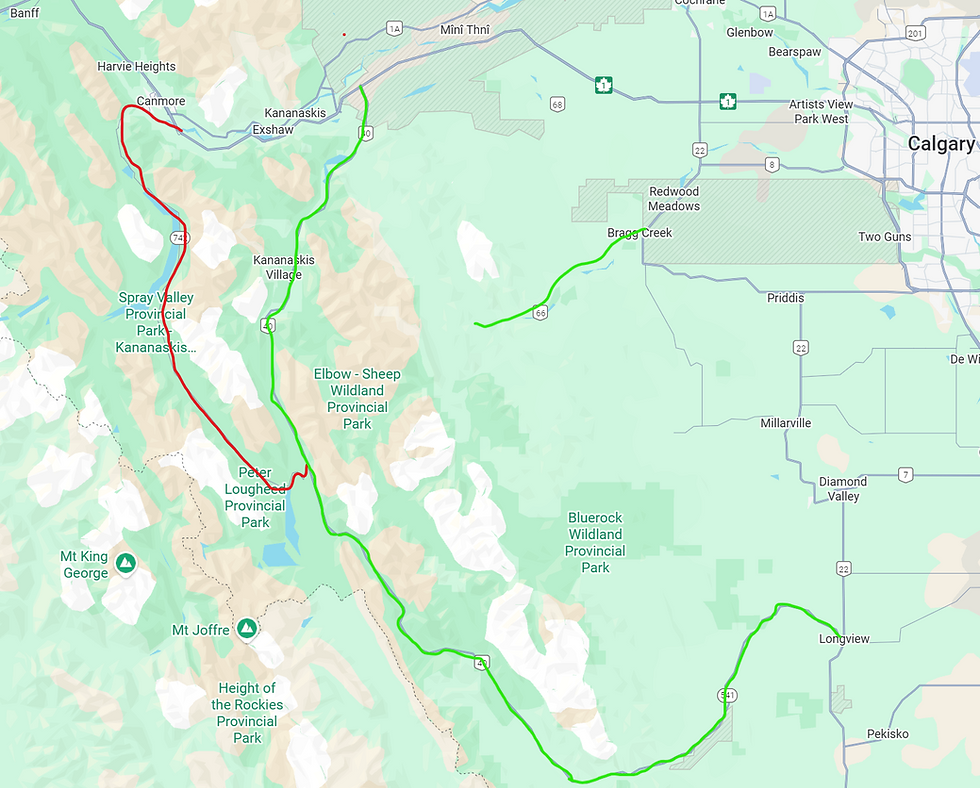
Getting There: Bragg Creek Versus Highway 40
Highway 40, also known as the Kananaskis Trail, is the highest paved public highway in Canada. It reaches its highest point at Highwood Pass at approximately 2,206 meters (7,238 feet) above sea level. Because of this elevation, Highway 40 experiences alpine conditions similar to high mountain passes in the Alps, with cooler temperatures, fast changing weather, and snow often lingering well into early summer.
This is also why the scenery along Highway 40 is so dramatic. You are driving directly through alpine terrain rather than skirting the foothills. It explains the sharper peaks, open valleys, and why this side of Kananaskis feels noticeably more rugged than the Bragg Creek area.
There are two main ways most people access Kananaskis from Calgary.
Via Bragg Creek and Highway 66
Heading west toward Bragg Creek is the quickest way to reach the northern parts of Kananaskis. From downtown Calgary, this is usually a forty five to sixty minute drive. This area transitions gradually from foothills to mountains and is characterized by rolling terrain, dense forest, river valleys, and lower peaks.
The Bragg Creek side is excellent for trail running, mountain biking, easier hikes, and shoulder season adventures. It is beautiful, accessible, and popular with locals. The mountains here are impressive, but they are not as steep or dramatic as what you find deeper into Kananaskis.
Via Canmore and Highway 40
If you want big mountain scenery, Highway 40 is where things level up.
Driving to Canmore first and then heading south on Highway 40 adds about thirty to forty five minutes compared to Bragg Creek, depending on traffic and conditions. It is worth every minute.
Highway 40 cuts straight through the heart of Kananaskis Country. The peaks are higher, sharper, and more dramatic. Alpine terrain dominates, and the sense of scale is immediate. This is where many of the classic Kananaskis hikes and mountaineering objectives are located.
If your goal is serious hiking, scrambling, or simply jaw dropping views, this is the side you want to be on.
The Spray Lakes Gravel Road: Scenic but Not Always Smart
From Canmore, it is possible to drive the gravel road along Spray Lakes Reservoir and connect through to Peter Lougheed Provincial Park.
This road is incredibly scenic, but it is not always the best choice.
Road conditions vary widely. After rain, during spring melt, or late in the season, the surface can be rough, potholed, or heavily corrugated. Rental cars and low clearance vehicles do not love it. Travel time is often longer than expected.
If your hike does not start directly off the Spray Lakes road, it is almost always better to take the fully paved Highway 40. It is faster, easier on your vehicle, and more predictable. Scenic shortcuts are great, but only when they actually save time or place you at your trailhead.
Standout Hikes in Kananaskis Country
Kananaskis is packed with world class hiking, from accessible half day outings to serious alpine objectives. These are a few that truly stand out.
Mount Smutwood
Mount Smutwood is an advanced hike and scramble and one of the most rewarding objectives in Kananaskis. It sits deep in Peter Lougheed Provincial Park and delivers massive views of surrounding peaks and valleys.
Distance is roughly 15 km round trip with about 1,200 m of elevation gain. This is not a casual walk. Route finding, exposure, and fast changing alpine weather all demand experience and solid fitness. For those with the skills, it is a top tier mountain day.
South Lawson Peak
South Lawson Peak is my personal favorite hike in all of Kananaskis and easily one of my favorite views anywhere in the Canadian Rockies.
It is surprisingly quiet for how good it is. If every Banff tourist knew about it, this trail would be far busier. I usually keep it somewhat secret, but if you are reading this, you have earned it.
The hike is steep and direct, roughly 8 km round trip with approximately 850 m of elevation gain. There is very little wasted movement. Expect a consistent climb.
Most strong hikers complete it in four to five hours total. It is a perfect half day objective and one you can comfortably start later in the morning with stable weather.

King Ridge
King Ridge sits close to South Lawson Peak and offers a similarly impressive alpine perspective.
The route is approximately 7.5 km round trip with around 800 m of elevation gain. Like South Lawson, it is steep, physical, and honest. The views from the ridge are expansive and feel far more remote than the effort suggests.
Mist Mountain
Mist Mountain is widely considered one of the most beautiful mountains in Kananaskis, alongside Mount Elpoca, which cannot be hiked.
The full summit hike is roughly 10 km round trip with about 900 m of elevation gain. However, what makes Mist Mountain truly special is that you do not need to summit to have an unforgettable experience.
About halfway up the route, there is a true natural hot spring. Sitting in a hot spring surrounded by wild mountain terrain is something few places still offer. This area sees fewer visitors than Banff, which makes the experience feel genuine and unfiltered.
Wildlife and Safety: This Is Real Wilderness
Kananaskis is quieter than Banff, but that also means it is wilder.
There have been bear attacks in Kananaskis. This is not a scare tactic. It is reality. Carry bear spray, know how to use it, and travel in groups whenever possible.
The southern parts of Kananaskis are especially active for wildlife. During spring and early summer, berry season drives intense bear feeding behavior. Bears are focused on eating and can be easily startled.
Make noise, stay alert, and treat the landscape with respect. This is their home first.
Camping in Peter Lougheed Provincial Park
Camping in Peter Lougheed Provincial Park is one of the best ways to experience Kananaskis properly.
There are two types of camping available.
The first option is reservable front country campsites. These can be booked online through Alberta Parks and are the safest option if you are planning a trip during peak season. Reservations open early in the year and popular weekends book out fast.
The second option is first come, first served camping. These sites cannot be reserved. You must arrive in person and claim an available site. During weekdays or shoulder season this works well. On summer weekends, arriving early in the day is critical.
Firewood can be purchased directly at the campground. You are not allowed to collect firewood yourself anywhere in the park. A bundle typically costs around $10. If you enjoy big fires, expect to go through three to four bundles per night.
Wildlife regularly moves through campgrounds. Moose, bighorn sheep, and grizzly bears are commonly seen. Always store food, coolers, and scented items in your vehicle. This is not optional.
Frequently Asked Questions
When is Kananaskis accessible?
Kananaskis Country is accessible year round. Highway 40 is plowed in winter, but conditions can change quickly. Many hiking routes are best from late June through September depending on snowpack.
Do I need a park pass?
Yes. A Kananaskis Conservation Pass is required for all vehicles parking in Kananaskis Country. This applies year round and can be purchased daily or annually through Alberta Parks.
What is the best time of year to hike?
Late July through early September offers the most reliable conditions for alpine hiking. Early summer often has lingering snow at higher elevations. Spring hiking requires extra caution due to wildlife activity and variable trail conditions.
Why Kananaskis Belongs on Your Alberta Adventure List
Kananaskis Country offers something increasingly rare. Big mountains, real wilderness, and space to explore without feeling herded from viewpoint to viewpoint.
It takes a bit more effort to reach than Banff, and that effort is exactly why it remains special.
If you are looking for authentic mountain experiences away from crowded parks, Kananaskis delivers every time.


Comments